

Bangladesh World Map: A Founder's Strategic Guide
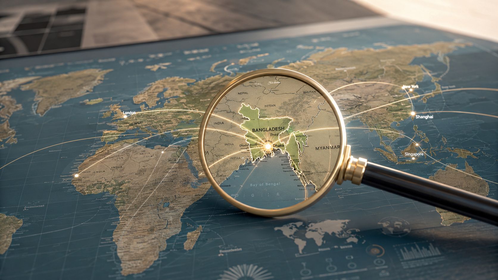
You're probably doing the same thing most founders do at the start. You open a Bangladesh world map, confirm where the country sits, notice India around it and the Bay of Bengal below it, then move straight to questions that the map doesn't answer.
Can we hire there? Where should we source from? Which city matters for port access? Where does flood risk start to distort delivery economics? Which regions matter if you're selling, not just shipping?
That's the problem. A simple map helps you locate Bangladesh. It doesn't help you operate in Bangladesh.
For a UAE or MENA founder, the right way to read Bangladesh is as a business map layered across logistics, administration, population concentration, and regional risk. If you're evaluating manufacturing, services, hiring, trade, or distribution, the map isn't background context. It's one of your first operating tools.
Why a Simple Map of Bangladesh Is Not Enough
You shortlist Bangladesh for sourcing, hiring, or distribution. Then the first real operating question hits. Which map are you using to make that call?
A basic Bangladesh world map shows the border, Dhaka, and nearby countries. That helps with orientation. It does not help you decide where to place inventory, which districts can support field execution, or how seasonal water exposure will affect delivery times and margin.
Bangladesh sits across one of the world's largest delta systems. Rivers, floodplains, and coastal exposure shape transport routes, land use, and disruption risk across the country. The national outline hides that. The same is true for administration. If you do not read Bangladesh through divisions, districts, and city clusters, you are not evaluating a market. You are looking at a silhouette.
That mistake shows up early. A UAE founder may compare straight-line distance and assume market access is simple. It is not. Internal movement, district-level administration, and exposure to flooding or congestion often decide execution quality more than headline proximity. A hiring-led company can make the same error by focusing on total population instead of the smaller set of urban centres where skilled labour, vendors, and support infrastructure are concentrated.
Use the map the way an operator should use it. As a decision filter.
The country outline is only the first layer. After that, switch to the map that matches the job:
- Administrative map for territory design, permits, partner coverage, and district-level rollout
- Physical map for route planning, flood-prone areas, and infrastructure constraints
- Economic concentration map for talent pools, demand clusters, and commercial hubs
- Socioeconomic map for service gaps, lower-competition zones, and expansion sequencing
This is the practical shift founders need to make. Stop treating geography as background context. Treat it as an operating system for market entry.
If you already use a Kuwait world map example to assess trade position and operating logic, apply the same discipline here. Bangladesh requires more layers because execution risk inside the country is higher and more uneven by region.
A useful Bangladesh world map should answer a short list of hard questions:
- Where to enter first
- Which city should anchor operations
- How goods move
- Where disruption risk cuts into margins
- Which regions need field validation before you commit capital
That is how you turn a map into a market entry tool.
Locating Bangladesh on the Global Stage
A founder looking at Asia on a world map has to make a fast call. Is Bangladesh a side market, a sourcing base, or a regional operating node? The right answer is the third one, but only if you read its location through trade access, border friction, and regional adjacency.
Bangladesh sits in South Asia, enclosed on three sides by India, touching Myanmar in the southeast, and opening to the Bay of Bengal in the south. That combination matters because it shapes how products enter, how suppliers connect, and which regional corridors are realistic versus theoretical.

Why this location matters commercially
Start with the coastline. Bangladesh has maritime access into the Bay of Bengal, which immediately puts ports, shipping times, and import-export economics on the table. If you source goods, evaluate contract manufacturing, or build a regional supply chain, coastal access is not a background detail. It affects landed cost, inventory buffers, and which operating model makes sense.
Then look at the land borders. India surrounds most of the country, which means Bangladesh operates beside one of the region's biggest economic systems while also dealing with the practical constraints that come with border-dependent movement. Myanmar adds a second regional edge, but for most founders, what matters is strategic position, not map trivia. Bangladesh sits at a junction between South Asia and the eastern trade routes that pull toward Southeast Asia.
If you have already used a Kuwait world map framework for evaluating trade position and regional operating logic, apply the same discipline here. Bangladesh deserves a more operational read because internal execution conditions vary much more by corridor, city, and region.
What the world map helps you answer
A global map is useful for first-pass strategy. It helps you answer whether Bangladesh belongs in your market selection shortlist and what role it should play.
| Map signal | Business implication |
|---|---|
| Surrounded largely by India | Strong exposure to South Asian trade flows, competitive pressure, and cross-border dependency |
| Connection to Myanmar | Relevance for firms tracking eastward regional positioning and frontier corridor potential |
| Bay of Bengal coastline | Direct impact on port access, shipping logic, and import-export viability |
Use this layer to make three early decisions. Should Bangladesh be tested as a sales market, a sourcing market, or both? Should your entry model prioritize sea access over inland distribution? Does your regional plan depend on South Asian adjacency, or will that create more complexity than value?
That is the limit of the world map. It gives you strategic relevance, not execution clarity.
For a founder, that distinction matters. A country can look well placed globally and still punish bad assumptions on routing, site selection, and regional rollout.
Reading the Physical and Political Landscape
Most founders underestimate how much Bangladesh's physical geography dictates operating reality. That mistake gets expensive.
Bangladesh sits in a low-lying deltaic setting where rivers and floodplains dominate the terrain. For infrastructure and logistics planning, river migration and low elevation are critical constraints, and small elevation differences materially change flood frequency and land-use suitability, according to USGS geospatial documentation referenced for Bangladesh planning.

Physical map first, then business model
If you're moving goods, building supplier networks, assessing warehousing, or planning site selection, the physical map should come before your financial model. In Bangladesh, terrain and water systems aren't side notes. They are operating constraints.
A district that looks close on a political map may behave very differently in practice because route stability, drainage, or flood exposure can disrupt movement and settlement patterns. This is why generic “distance to customer” analysis often fails in delta markets.
Use the physical map to pressure-test:
- Route reliability for inbound and outbound goods
- Site viability for storage, light industry, or service centres
- Urban expansion assumptions around major commercial zones
- Climate exposure when selecting partners or regions
Political boundaries still matter
The second layer is the administrative map. Bangladesh isn't one smooth market. It is governed through formal units that shape local planning, service delivery, and regional management.
That matters when you're allocating sales ownership, selecting distributors, mapping supplier catchments, or deciding where local relationships matter most. A founder who only sees “Bangladesh” sees one market. An operator sees a set of regions with different execution conditions.
Here's a useful way to interpret the map:
| Map layer | Founder question it answers |
|---|---|
| Physical geography | Can we move goods and build reliably in this area? |
| Division and district boundaries | How should we segment operations and local accountability? |
| Coastal and river systems | Where does transport advantage become transport risk? |
A quick visual helps if your team is still thinking too abstractly:
If your Bangladesh entry memo doesn't include a physical map review, it's incomplete.
Weak expansion plans usually break at this point. Founders discuss market potential, then ignore the geography that determines whether the plan can survive contact with reality.
Mapping People and Economic Power
You are choosing a launch city, building a hiring plan, and pricing delivery promises. A basic Bangladesh map will not help. You need to know where people, spending power, decision-makers, and trade flows cluster.
Bangladesh packs a very large population into a relatively small territory, creating intense concentration in a few urban and industrial corridors, as noted in Wikipedia's Bangladesh reference page. For a founder, that changes four operating assumptions fast. Customer acquisition can scale faster in dense cities. Hiring gets easier where formal employers, agencies, and universities already cluster. Distribution improves where roads, warehouses, and buyers sit close together. Risk rises if you overbuild around one city without a second node.
Dhaka controls more than demand
Dhaka is where commercial gravity shows up in practice. Corporate buyers sit there. Senior talent sits there. Regulators, banks, service firms, and local decision-makers often route through Dhaka even when end customers are elsewhere.
Treat Dhaka as your control tower if your model depends on B2B sales, hiring managers, partnerships, fundraising access, or central support functions. A founder who skips Dhaka usually pays for it with slower recruiting, weaker partner access, and longer sales cycles.
That does not mean you must start with a Dhaka-only footprint. It means your Bangladesh plan needs a Dhaka position, whether that is an office, a sales team, a country manager, or a partner network anchored there.
Chittagong changes the operating model
Chittagong matters for a different reason. It is the country's main trade gateway and a core industrial node. If your business depends on imports, exports, factory relationships, freight coordination, or port-linked supply chains, Chittagong belongs in your first operating map.
This is the split founders need to get right. Dhaka concentrates management, talent, and commercial coordination. Chittagong concentrates movement, shipping, and trade-facing operations. If you sell software, professional services, or urban consumer products, Dhaka usually leads. If you move goods, source inputs, or support manufacturers, Chittagong can shape margin more than Dhaka does.
Aerial context helps here. This guide for paving contractors on aerial images is built for a different industry, but the lesson applies. Top-down visuals reveal site access, transport links, density, and surrounding infrastructure faster than a plain political map.
Read concentration like an operator
Do not stop at "large market." That is boardroom language, not operating logic. Use concentration to answer execution questions:
Where can we hire fast?
Dense urban centres usually give you deeper pools for sales, support, operations, and contracted services.Where should we launch first?
Start where buyers cluster tightly enough to lower CAC, shorten routes, and simplify field coverage.Where do we need a second node?
If revenue sits in Dhaka but product movement depends on the port, split commercial leadership from logistics early.Where is concentration becoming exposure?
Heavy dependence on one city raises disruption risk, especially for delivery times, staffing continuity, and partner redundancy.
A practical founder filter
Use one question. Are you entering Bangladesh to access people, move goods, or do both?
If the answer is people, build around Dhaka first. If the answer is goods, map Chittagong and its surrounding industrial connections before you commit headcount elsewhere. If the answer is both, design a two-node plan from day one and avoid forcing one city to do two jobs badly.
Founders used to expansion playbooks from Gulf hubs often misread this split. Bangladesh rewards operational specialization more than centralization. If your team has only scaled through one-city command models, review these global expansion lessons for UAE startups entering new markets before locking your Bangladesh structure.
The Maps That Drive Business Decisions
Most founders use the wrong map because it's convenient.
They pull a political map, mark Dhaka, maybe mark Chittagong, and act as if they've done market analysis. They haven't. They've done orientation.
Bangladesh's governance structure includes 8 divisions, 64 districts, and 492 upazilas, and that granularity is what founders need for logistics, sourcing, service planning, and regional sizing, according to WorldMaps.info's Bangladesh administrative breakdown.
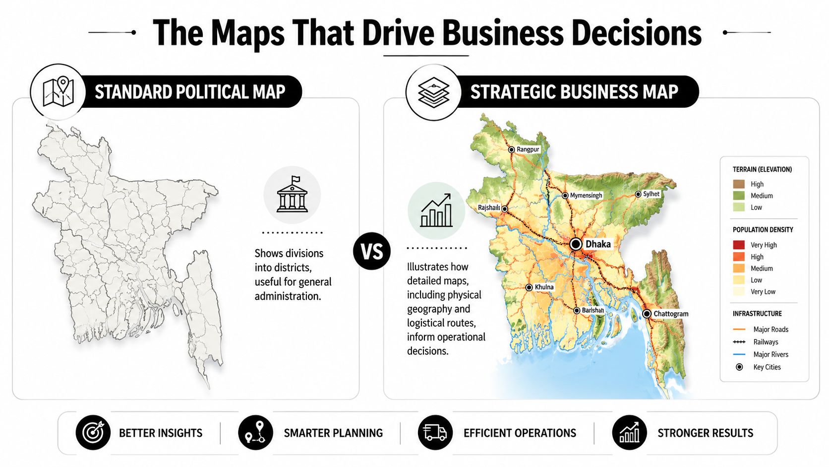
The country outline is too blunt
A national border map is useful for a board slide. It's weak for execution.
If you're planning last-mile delivery, field sales coverage, supplier onboarding, or service deployment, upazila-level thinking is often more useful than country-level or even district-level thinking. The operational question isn't “Are we in Bangladesh?” It's “Which sub-regions can we serve reliably and profitably?”
What a strategic business map should include
A serious Bangladesh map stack should combine multiple layers. Not all in one dashboard on day one, but all in your planning process.
Administrative layer
Use divisions, districts, and upazilas to assign ownership, assess partner footprint, and sequence expansion.Terrain and flood layer
Overlay physical exposure before locking service promises, delivery windows, or facility assumptions.Commercial concentration layer
Mark where major business activity, urban density, and transport nodes intersect.Infrastructure layer
Focus on roads, port relevance, and route practicality rather than straight-line distance.
If your team works with imagery for site selection, corridor checks, or land-use interpretation, this guide for paving contractors on aerial images is useful because it sharpens how to read overhead imagery operationally, not aesthetically. The same discipline applies when evaluating industrial land, access roads, or expansion zones in Bangladesh.
A simple comparison
| Map type | Good for | Bad for |
|---|---|---|
| World map | Location awareness, macro positioning | Execution planning |
| Political map | Divisions, districts, governance structure | Physical risk and route realism |
| Business map with layered data | Territory design, sourcing, serviceability, market sequencing | Quick visual simplicity |
The founder using a standard map sees one country. The founder using layered maps sees operating zones, bottlenecks, and priority corridors.
What to do instead
If you're preparing market entry, ask your team to produce a Bangladesh decision pack with these three outputs:
- A district and upazila shortlist tied to your first commercial objective
- A transport and risk overlay for those target areas
- A phased launch map showing where you will not operate initially
That last one matters. Expansion plans fail because teams define target zones and ignore exclusion zones.
If you need a broader framework for structuring this kind of work across markets, these global expansion tips for UAE startups are a useful companion. The core principle is the same. Don't enter a market at country level when the actual operating reality is regional.
Actionable Map Resources and Use Cases
You are reviewing a Bangladesh launch on Friday. Sales wants Dhaka first, operations wants Chattogram, and finance wants the lowest-cost districts. A plain Bangladesh world map will not settle that argument. A working map stack will.
Use four map layers and tie each one to a decision. Administrative boundaries help you assign partner coverage, licensing follow-up, and field ownership. Physical maps show where flood exposure, river crossings, and road conditions can break delivery times or raise operating cost. Satellite views let your team verify industrial access, warehouse surroundings, and actual built density before anyone books a site visit. Socioeconomic maps help you judge where demand may be constrained by affordability, public-service gaps, or infrastructure weakness.
The most overlooked input is socioeconomic geography. Bangladesh's official poverty mapping work is useful because it shifts the conversation from “Where is the market?” to “Where will our model work first, and where will servicing costs rise?” Use the government's Poverty Map of Bangladesh 2022 for territory screening, service-gap analysis, and rollout sequencing, as outlined in the official Poverty Map document.
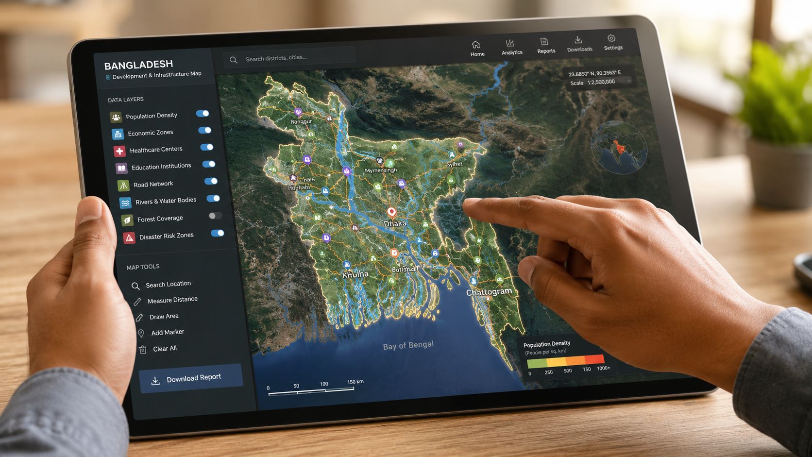
Which map to use for which decision
Use this decision filter:
Political map
Use it to set district priorities, sales territories, distributor boundaries, and government-facing responsibilities.Physical map
Use it before you price logistics, choose facility locations, or promise service levels outside the main urban corridors.Satellite or aerial view
Use it to inspect factory surroundings, truck access, congestion risk, nearby settlement patterns, and expansion room.Socioeconomic map
Use it to identify where low purchasing power, weak infrastructure, or service shortages will affect customer acquisition, staffing, or unit economics.
A fast operating checklist
Before you approve spend, ask five questions:
- Which districts are phase-one districts, and what commercial logic puts them there?
- Which roads, river routes, or seasonal conditions could disrupt delivery or field operations?
- Which city gives you management talent, and which city gives you trade access?
- Which districts are excluded in phase one because the economics or execution risk are wrong?
- What does the poverty or disparity layer imply about affordability, service design, and distribution cost?
This is how founders avoid vague country plans. Bangladesh entry should be approved as a sequence of operating zones with clear inclusion and exclusion criteria.
If you need help turning those layers into a market-entry plan, this guide to international business consulting for cross-border expansion is a useful starting point.
Give your strategy or operations lead a hard deadline. By the end of the week, they should bring you three Bangladesh map views: administrative, physical, and socioeconomic, plus a recommendation on where not to launch first. If they bring back a country outline, they have not done the job.

Popular posts


The premier community for tech founders, investors, and builders. Connect, collaborate, and grow together.