

World Map Saudi: KSA Expansion & MENA Logistics 2026
Building in MENA? You don't have to do it alone.
Join 300+ founders in the Founder Connects Residency. Monthly squad calls, warm intros, $3M+ in perks, and much more. All for less than your monthly coffee budget.

The most common advice around a world map of Saudi Arabia is also the least useful for a founder. It tells you where the Kingdom sits, names a few neighbours, and stops there.
That's fine for a school atlas. It's weak input for market entry.
If you're building from the UAE, Saudi geography isn't just location. It's distribution logic, operating cost, expansion sequencing, and competitive response time. A static map won't tell you where fulfilment gets harder, which side of the country changes your import approach, or why one launch city can create an advantage while another creates drag.
Why a Standard World Map of Saudi Is Not Enough
Most pages ranking for World Map Saudi answer the easy question: where is Saudi Arabia? They usually show a locator map, a flag, and a short list of neighbouring countries. That misses the business question UAE founders need answered.
The more useful lens is this: what does Saudi Arabia's position on the map mean for cross-border trade, travel, and operating models from the UAE? That gap is exactly what many map pages leave open, as noted in Geology.com's Saudi Arabia map context.
Location is not strategy
A founder entering KSA doesn't win by knowing Saudi is in the Middle East. You win by knowing how that position affects:
- Your first entry route. Land, air, and sea don't solve the same problem.
- Your launch geography. Riyadh, the western corridor, and the eastern side create different execution patterns.
- Your service promise. Delivery expectations break when teams underestimate inland distance.
- Your UAE operating model. Some companies can serve KSA from Dubai first. Others hit limits fast and need local depth sooner.
A map becomes useful when it changes a decision.
Practical rule: If your map doesn't help you choose entry point, warehouse logic, or target region, it's reference material, not strategy.
What founders usually get wrong
Three mistakes show up repeatedly.
- They treat KSA as one market. It isn't. Demand, routes, and operating friction vary by region.
- They over-focus on border proximity. Being geographically near Saudi from the UAE doesn't mean your internal Saudi distribution is simple.
- They confuse visibility with readiness. Seeing the Kingdom on a global map is easy. Designing a workable expansion path is harder.
For a UAE-based founder, the point of a world map Saudi search shouldn't be “find the country”. It should be “read the country well enough to enter it intelligently”.
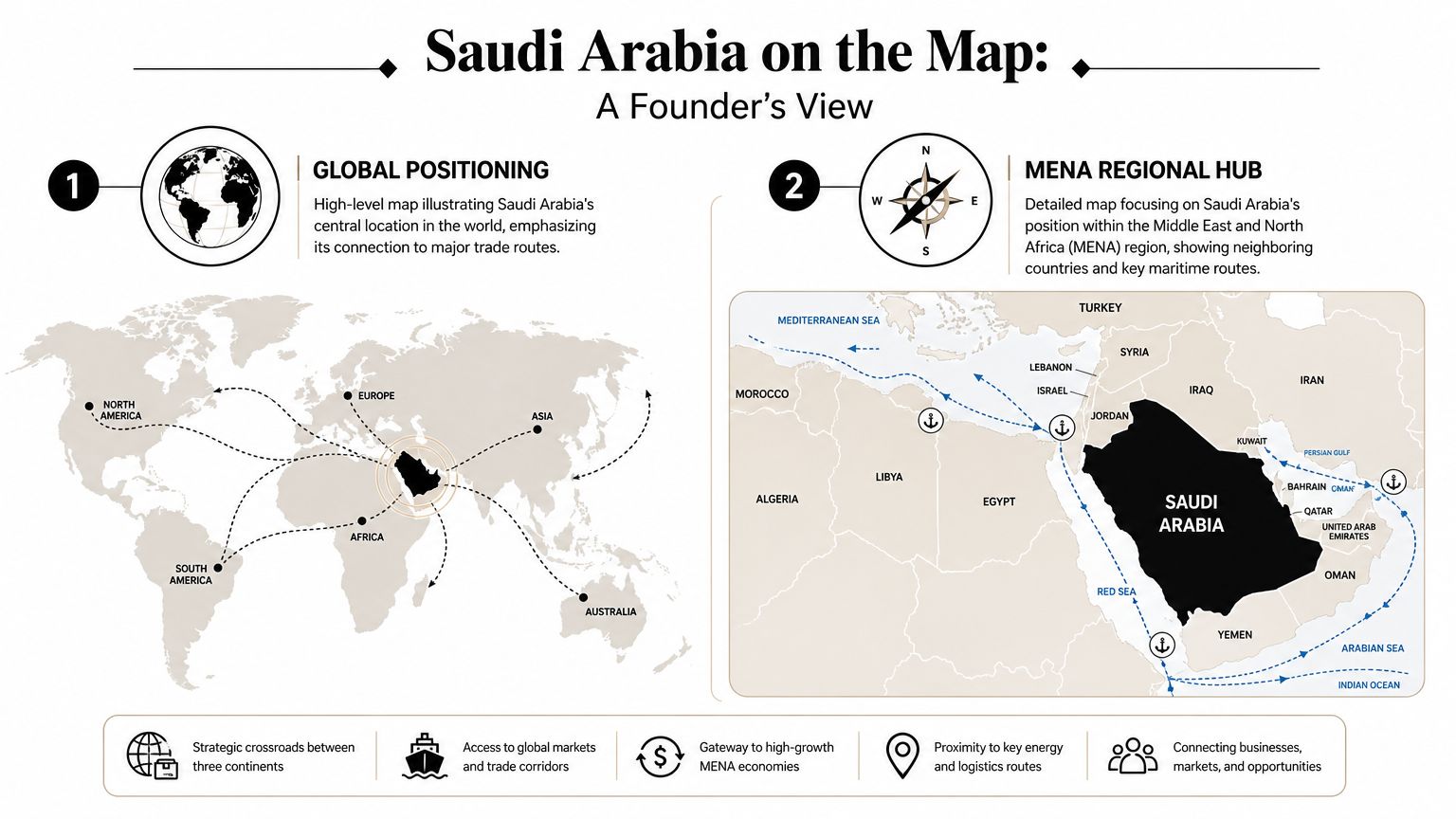
Saudi Arabia on the Map A Founder's View
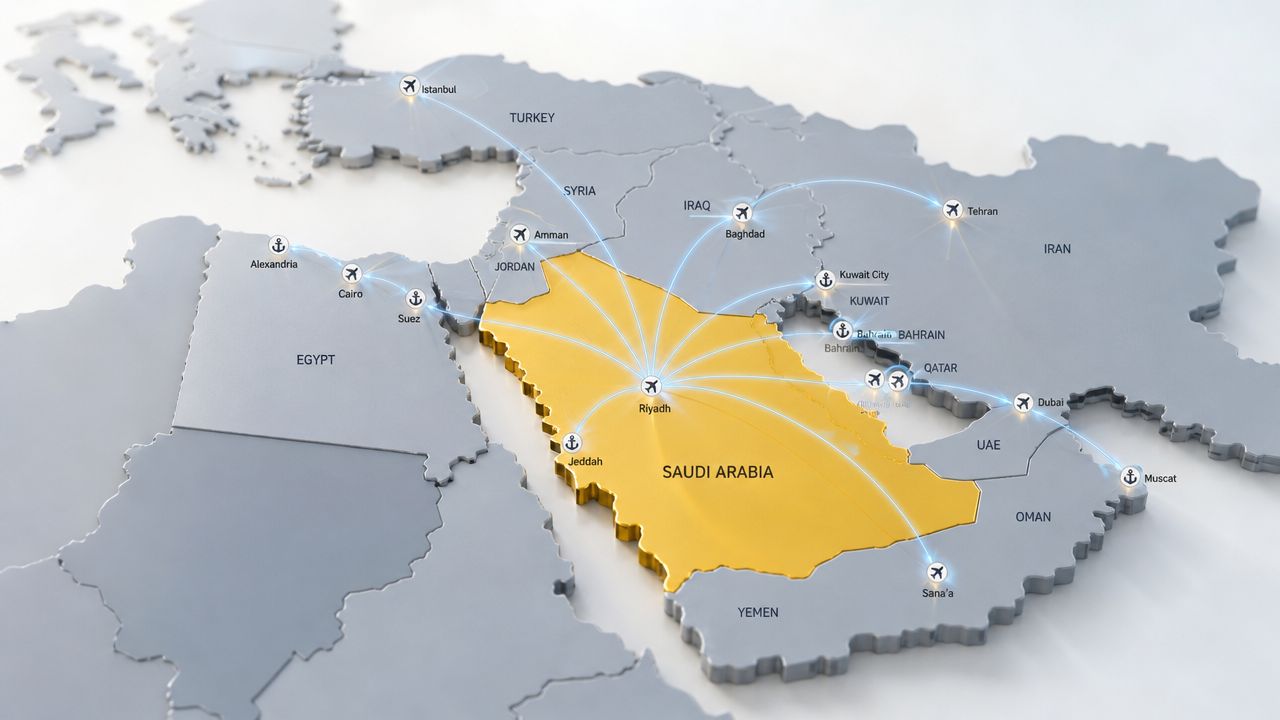
Saudi Arabia's strategic value starts with scale and position. It is the largest country in the Middle East, covering about 2.15 million square kilometres, and it shares land borders with Jordan, Iraq, Kuwait, Qatar, the United Arab Emirates, Oman, and Yemen, while also connecting the Red Sea and the Persian Gulf, according to Infoplease's Saudi Arabia map overview.
Why that position matters in practice
A founder in Dubai or Abu Dhabi should read that map in two ways at once.
First, Saudi sits as a land bridge between the Levant, the Gulf, and the Red Sea corridor. That gives it obvious regional importance. More importantly, it means Saudi can be approached from more than one commercial direction. Your route choices shape cost, speed, and complexity before you even talk about customer acquisition.
Second, Saudi has two coastlines. That matters because market entry isn't only about crossing the UAE-KSA land boundary. It's also about deciding whether your supply chain is better served through Gulf-facing infrastructure or Red Sea-facing infrastructure, depending on where your goods originate and where demand sits.
The founder's quick read of the map
If I were reviewing a founder's KSA plan from scratch, I'd want them to answer these questions from the map alone:
- Which side of Saudi matters more to your business? East-facing, west-facing, or inland?
- Are you building for one city first or a wider corridor?
- Will your team manage KSA from the UAE initially, or will distance weaken execution?
- Does your product depend on physical movement, local installation, or repeat visits?
Saudi's shape matters less as an outline and more as an operating surface. The question isn't where it is. The question is how far your business model can stretch across it.
A SaaS founder may look at the same map and see sales coverage. A consumer brand sees fulfilment lanes. An industrial supplier sees port logic and inland transfer risk. The map is the same. The reading changes with the model.
Beyond Borders Mapping KSA's Economic Engine
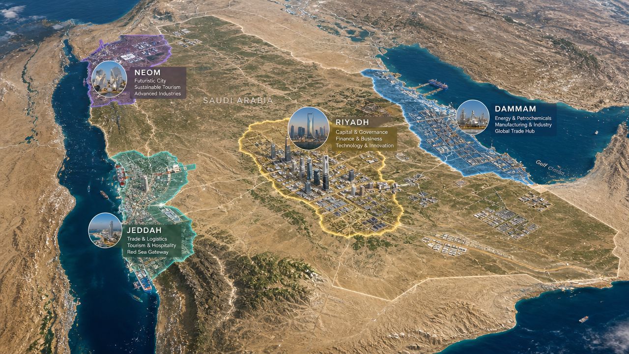
Saudi Arabia doesn't function as one flat commercial zone. Its map reflects a deeper economic structure. Britannica identifies the main geographic regions as the Hejaz in the west, Najd in the central heartland, and the oil-rich Eastern Region, and notes that oil was discovered in 1938, with development later concentrating heavily in the east through industrial corridors and port infrastructure that still shape regional trade routes today, as outlined in Britannica's Saudi Arabia profile.
Read the regions, not just the border
For founders, those regions create very different operating conditions.
The western side, associated with the Hejaz, is commercially important because it connects to the Red Sea corridor and major urban activity on that side of the country. If your business depends on western market access or Red Sea shipping relevance, this area changes your planning.
The central heartland, Najd, shifts the lens from maritime access to inland execution. It is in this region that many founders comprehend Saudi scale. What looks manageable on a regional map can become an expensive service footprint once you start committing to delivery windows, installation schedules, or field sales movement.
The Eastern Region matters because historic oil-led development concentrated infrastructure and industrial logic there. For B2B, industrial supply, heavy goods, and Gulf-facing trade, this part of the map often matters earlier than first-time entrants expect.
What works for first-entry focus
A practical way to think about KSA is to separate headline visibility from operational suitability.
- Pick the region that matches your demand pattern. Don't choose a city because it's famous. Choose it because your customers, routes, and support model align.
- Match your product to the region's economic shape. Consumer, enterprise, industrial, and service businesses rarely need the same launch geography.
- Avoid the “nationwide on day one” trap. In Saudi, overreach shows up quickly in fulfilment, support, and sales coverage.
A useful comparison is how founders read neighbouring markets with more nuance instead of treating them as a single block. This short piece on the Kuwait map in world map is a good reminder that regional geography only becomes useful when it's translated into operating choices.
A sharper founder question
Don't ask, “Where should we expand in Saudi?”
Ask, “Which Saudi region gives us the strongest first proof of execution?”
That question is better because it forces trade-offs. A prestige launch location may look strong in a deck and still be the wrong place to learn. The best entry geography is often the one that lets your team control service quality, iterate faster, and build a repeatable corridor before broadening coverage.
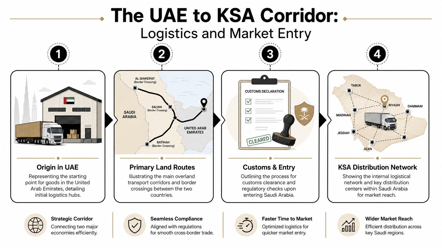
The UAE to KSA Corridor Logistics and Market Entry
Saudi Arabia's physical scale changes everything once goods move. The country covers about 2,149,690 square kilometres, with land borders totalling 4,431 km, and that scale materially affects route planning, port choice, and logistics models for the UAE-Saudi corridor, according to Landinfo's Saudi Arabia geodata profile.
A founder usually feels this in the second stage of planning, not the first. The first stage is optimism: “We're next door.” The second stage is reality: “Next door to the border isn't the same as close to the customer.”
The real trade-off between land, air, and sea
For UAE founders, transport mode should follow business model, not habit.
| Transport Mode | Typical Transit Time | Relative Cost | Best For |
|---|---|---|---|
| Land | Fast to moderate, depending on border clearance and destination inside KSA | Lower to moderate | Regular replenishment, cross-border road freight, staged market entry from UAE |
| Air | Fastest | Highest | Urgent, high-value, lightweight, launch-critical shipments |
| Sea | Slower | Often lower for larger volumes | Bulk movement, lower urgency inventory, planned restocking |
This table is intentionally qualitative because the right answer depends on shipment profile, customs handling, destination city, and service promise.
What usually works
Many UAE startups start with a UAE-led operating base and use Saudi as an expansion market before building deeper local infrastructure. That approach often works when:
- Your product is lightweight or high-margin
- Customer support can be handled remotely
- Demand is still being validated
- You need optionality before locking into a larger footprint
Land routes can be attractive because they support frequent movement and tighter inventory control. But they also introduce border dependency, document discipline, and handover complexity. Air can rescue a launch or protect an enterprise relationship, but it becomes a poor long-term answer if your unit economics are already tight. Sea can work well for planned replenishment, though it demands better forecasting and less operational improvisation.
A useful external example is Kogifi's market expansion announcement, which is worth reading not for numbers, but for the broader signal it gives about how companies frame Saudi entry as a deliberate regional move rather than a casual neighbouring-market test.
The corridor breaks when internal KSA planning is weak
Founders often spend too much time on the UAE-to-Saudi crossing and too little on what happens after entry. That's where cost and customer experience drift.
If your shipment enters Saudi smoothly but your internal distribution plan is vague, you haven't solved logistics. You've only solved border crossing.
This matters especially for businesses selling physical goods, managed services, or anything requiring repeat touchpoints. Teams in this category should also study the operating patterns of newer supply-chain players and systems integrators. This roundup of logtech startups working on supply chain logistics innovation is useful because it shows the kind of execution layer founders increasingly need around visibility, routing, and last-mile coordination.
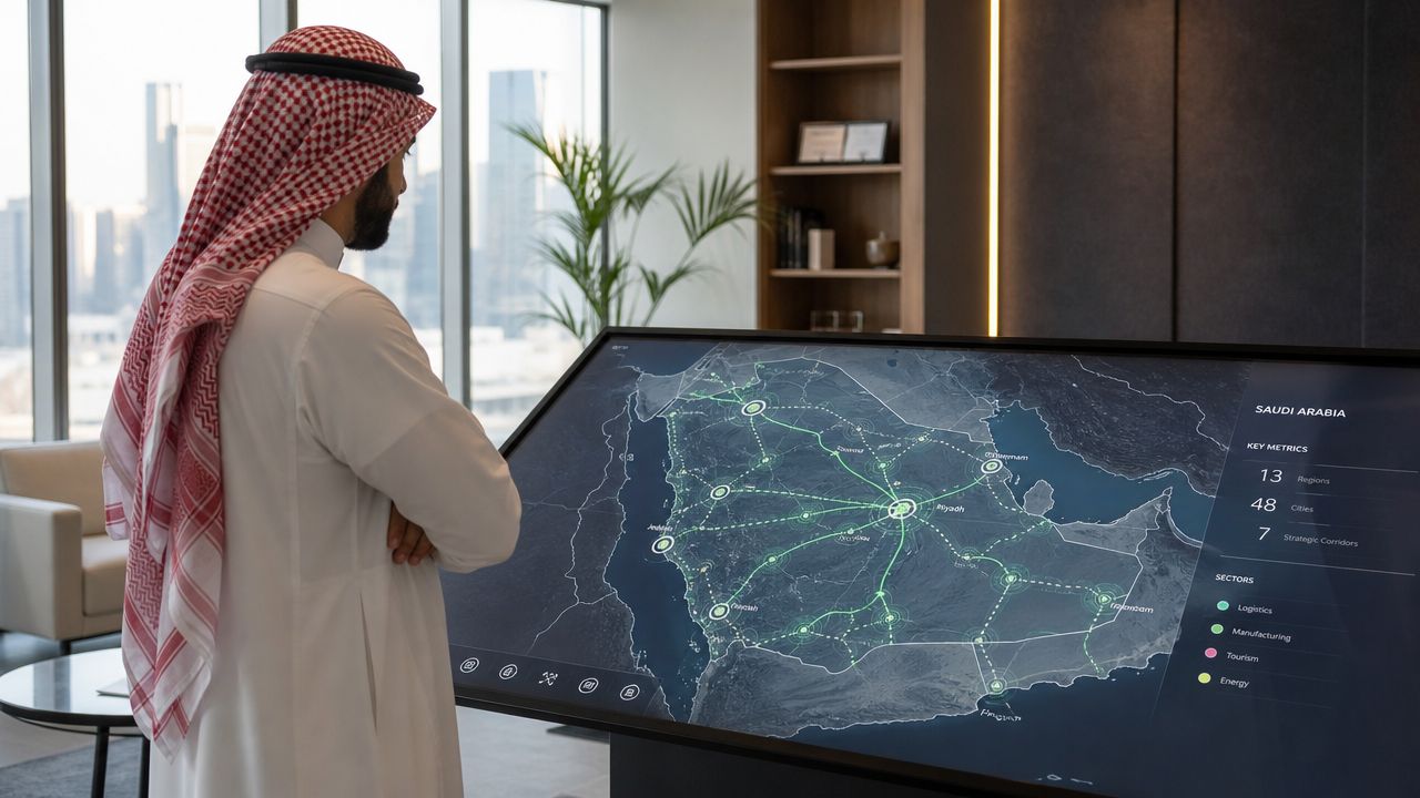
A quick visual summary helps if you're aligning team members across functions:
A practical entry rule
Use one primary corridor and one fallback corridor.
If land is your main route, decide in advance what triggers an air exception. If sea supports bulk stock, decide who owns forecast discipline. The founders who handle KSA well don't just choose a route. They choose a route hierarchy.
A Strategic Framework for Reading the Saudi Map
The best way to use a world map Saudi search isn't to collect visuals. It's to build a decision framework. Founders don't need more map files. They need a better way to interpret geography before committing budget and team attention.
The four-part read
Use this checklist before your first Saudi launch meeting.
Market concentration
Where are your most likely buyers concentrated first: east, west, or central Saudi? If you can't answer that clearly, your launch geography is still too broad.Movement requirement
Does your product move once, often, or continuously? A one-time shipment business reads the map differently from a business with returns, maintenance, or field sales visits.Service tolerance
How much delay can your customer tolerate? If the answer is “almost none”, your map should be read through response coverage, not just freight cost.Control point
What is the one point in the route you most need to control: import, warehousing, local delivery, or account management? The map gets clearer once you know where failure would hurt most.
Two different businesses, two different maps
An e-commerce brand should read Saudi by inventory placement and customer promise. If delivery speed and stock availability shape repeat purchase, then geography directly affects retention. The wrong launch area can force expensive fulfilment decisions before the brand has stable demand.
A B2B SaaS company reads the same geography through sales territories, account access, and implementation travel. In that case, the main map question is less about freight and more about field coverage, partner access, and how fast account teams can support deals once they enter pipeline. For teams managing distributed field activity, this practical guide to outside sales territory management is useful because it translates territory logic into rep planning and service discipline.
Operator's view: Don't ask whether Saudi is one expansion. Ask how many operating territories your business creates inside Saudi.
The one-page exercise to run this week
Take a blank page and split it into three columns:
- Target customer location
- Operating route
- Failure risk
Then fill in one line for each proposed launch region. This works well because it forces the commercial team and the operations team to describe the same geography in the same document. Misalignment shows up quickly.
If a region looks attractive commercially but weak operationally, that's not a no. It's a sequencing issue.
Your KSA Mapping Toolkit High-Res Maps and Resources
Once you stop treating Saudi maps as decoration, the toolkit changes. You don't just need a clean political outline. You need different map types for different decisions.
A key gap in mainstream content is that it rarely surfaces the territorial and boundary complexity behind Saudi Arabia's modern map. University map collections and similar archives are useful because they offer political, physical, and historical views that explain not just what the Kingdom looks like, but why that shape matters geopolitically, as highlighted by the University of Texas Saudi Arabia map collection.
What to use and when
Here's the practical stack I'd recommend.
Political maps
Use these when your team needs a fast orientation around borders, neighbouring states, and broad regional positioning. Good for board decks and first-pass market planning.Physical and terrain maps
Use these when movement, inland reach, or corridor assumptions need pressure-testing. They're especially useful for operators who are underestimating how a large territory changes coverage quality.Satellite imagery
Use this when you need infrastructure context rather than labels. It helps with industrial zones, port surroundings, urban spread, and route reality.Historical boundary maps
Use these when your work touches policy, long-horizon investment, or geopolitical interpretation. They're less relevant for day-to-day fulfilment, but useful when you need the “why behind the map”.
Build your own decision layer
The most useful internal map usually isn't downloaded finished. It's assembled.
Add your own layers such as:
- Sales hotspots
- Current or planned delivery zones
- Partner coverage
- Customer service response limits
- Warehousing or stocking assumptions
That's the point where a map stops being generic internet content and starts becoming company infrastructure.
One resource habit worth keeping
Look at Saudi through more than one national comparison. If your team is expanding across multiple corridors, it helps to compare how different countries appear on the world map and what those differences mean operationally. This piece on the Bangladesh world map is a useful example of how map reading becomes more valuable when tied to market context rather than simple location.
Your next action is simple. Open one political map, one satellite map, and one internal planning sheet. Then answer a blunt question: which Saudi geography are we built to serve first?
If you're a founder in the UAE or wider MENA region and want sharper thinking on expansion, operations, and decision-making, Founder Connects is built for that. It brings founders into high-signal peer groups, practical conversations, and curated introductions that help turn plans into progress.

Building in MENA? You don't have to do it alone.
Join 300+ founders in the Founder Connects Residency. Monthly squad calls, warm intros, $3M+ in perks, and much more. All for less than your monthly coffee budget.
Popular posts


The premier community for tech founders, investors, and builders. Connect, collaborate, and grow together.